Scenic Trails, Indigenous Culture, Tea Plantations, Waterfalls and Much More
Text | Rick Charette
Photos | Ray Chang
Wild boars and alpine-train rails plus heritage trails – that’s what Alishan’s north region is made of. And indigenous arts and crafts and evening feasts and DIY experiences. And slow-paced small old villages and soaring mist-caressed peaks and warm-hearted homestays. And, as you’ll discover by reading on, much else to nourish the city-fatigued soul as well.
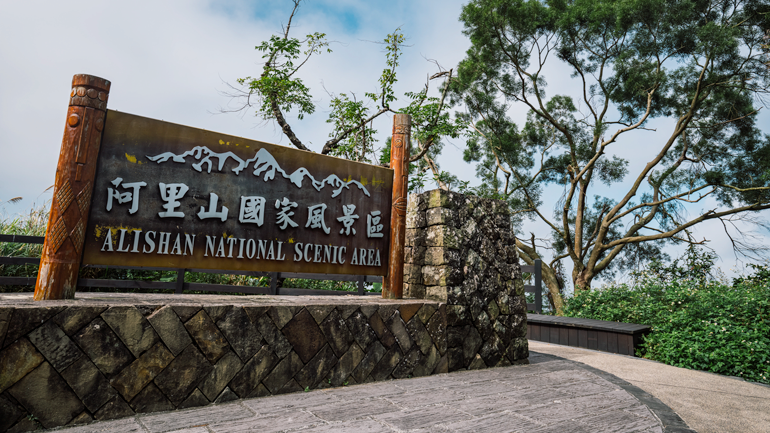
For most tourists, local and from overseas, the “Alishan” brand means a single place – the Alishan National Forest Recreation Area. But this captivating, oft enchanting, oft bewitching tourist-busy alpine enclave of soaring coniferous trees is merely one part, and a small portion at that, of the far-flung Alishan National Scenic Area (www.ali-nsa.net). In this Feature we visit the comparatively slow-paced, tourist-quiet north section, formally called the Northwest Corridor, on a leisurely 3-day trip. This region attracts the type of traveler that likes to spend days on trails used by locals for generations and nights in local villages rather than in tourist hotels.
Day One
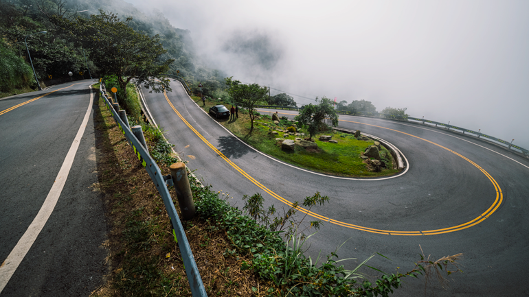
Most visitors access the NSA from the island’s western plains via Provincial Highway 18, which up among the peaks slices along mountainsides high over deep valleys, presenting the wide-eyed traveler with magnificent views of distant cloud-massaged crowns and jagged, sheer rock faces. On this trip we instead accessed the area via County Route 162A, which is much quieter, much narrower, much more twisting, with forest crowding in much closer.
Taiping
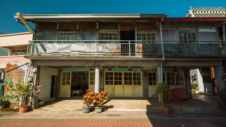
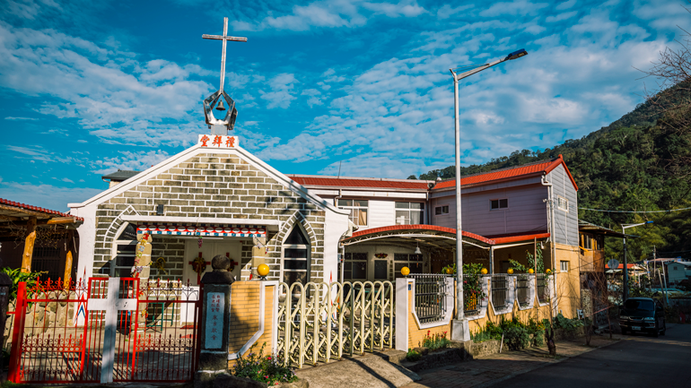
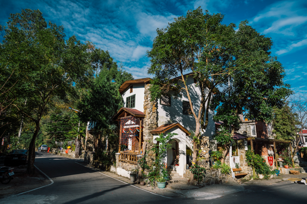
On the way to our first major stop, Bihushan (“Mt. Green Lake”) Tourist Tea Garden, we navigated the highway’s dramatic Taiping 36 Bends section, and then spent pleasant time ambling along Taiping Old Street. The exuberantly sinuous 36 Bend section stretches from 100 to nearly 1,000 meters above sea level; each 180-degree turn has a prominent sign with the bend number and the names (in Chinese) of nearby sights. The views of the western plains from the higher turns are superb. Taiping, which means “Great Plateau,” is a tea-farmer village. The slopes immediately surrounding the large flat area on which it sits are covered by dense forest. Traditional red-brick walling, wood-frame windows, and bright-blue paint are prominent among the Old Street’s hoary residences and shops.
Bishan Tourist Tea Garden
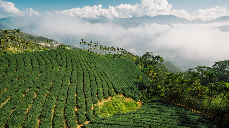
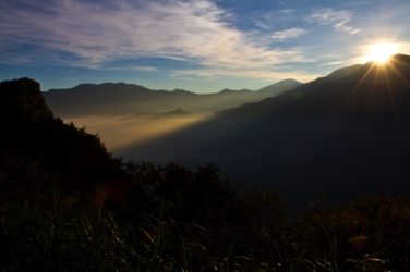
Alishan is renowned for high-quality high-mountain tea, and Bihushan Tourist Tea Garden is a photophile’s dream come true. The entire rounded mountain-head on which it is planted is sculpted with tight rows of Camellia sinensis, as neat as topiary, cut through with boardwalk trails. The sweeping panorama taken in from the trails or viewing platform before the open-front visitor center/restaurant is powerful. The waters of the rough river far below churn this way and that, on their short, impatient journey to the sea. Renowned Mt. Jade and Mt. Hehuan make cameos on clear days far off in the distance, as can a high slope-hugging arcade section of the gravity-defying Alishan Forest Railway. This tea-plantation mountaintop, often shrouded in cloud and mist, is a popular platform for watching Alishan’s celebrated sunrises, sunsets, and “sea of clouds” phenomenon – dense clouds roll into the abyss-like valleys like ocean tides, savored by tourists from eagle-eye vantage points.
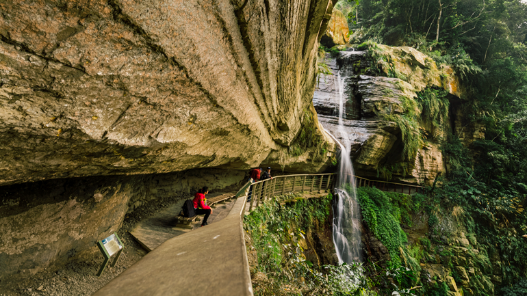
Longgong Waterfall
The 3.3km Zhukeng Stream Trail has a trailhead at each end on Highway 162A, west of Ruifeng village. Formerly called the “Old Charcoal Way” – early residents used it to take charcoal off the mountain to trade – it passes over 12 bridges, each of different design. There are a number of cataracts, hikers’ grand prize the 120m-high Longgong (“Dragon Palace”) Waterfall, reached via a dead-end side trail about mid-way along the main trail. This is a “hanging valley waterfall,” and as it shoots out into space the waters do indeed seem to hang momentarily in mid-air before making their way to the bottom of the deep gorge here. Behind the lofty natural artwork is Water Curtain Cave, through which the side trail runs.
Day Two
Green Tunnel
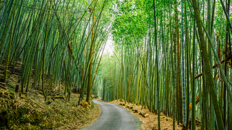
Next morning, we hit the trails right after breakfast – and stayed on them most of the day. First on our to-do list was the charming, long Green Tunnel, accessed via a short side road that begins right at sleepy Ruili village. You’re immersed in a lush forest of tall bamboo, walking along what is in fact a narrow road, not a trail (vehicles exceedingly few). Paved and gentle-graded, this spot is also popular with local folk, who come here for their daily constitutionals. In late winter/early spring you’ll also see them happily going “off-road,” digging up bamboo shoots to sell or eat.
Youth Ridge Trail
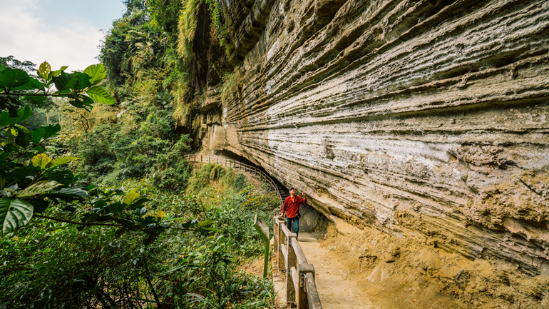
Then we launched ourselves on the challenging, visually thrilling 2km Youth Ridge Trail at the highway-side trailhead in Ruili village, across from Ruili Elementary School. In the past this was an important trade route. The 1,000-meter-long Haohan (“Hero”) Slope has an average grade of 60 degrees – yes, 60. Porters who could tackle it without stopping were praised for their “youthful bodies” – origin of the “Youth Ridge” moniker.
There is a lost world Jurassic Park-like atmosphere at the bottom of the gorge. I half-expected to see a pterodactyl come swooping by, eyeing us as potential lunch. The countless bat-roost holes in the Bat Cave were formed over millions of years by river erosion. The deep grooves in the mesmerizingly striated Swallow Cliff are also erosion-etched, the softer sandstone levels wearing away faster than the harder shale.
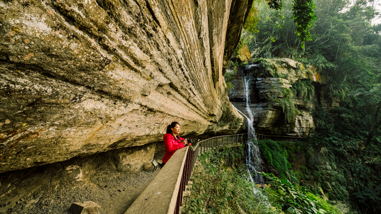
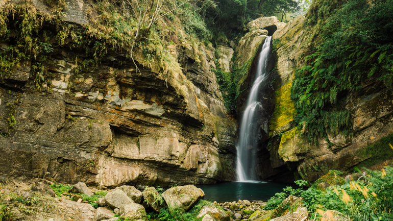
Yuntan Waterfall
A few kilometers further west along highway 166 is the entrance to the steep 600-meter Yuntan Waterfall boardwalk path and, just before it, Yuantan Natural Eco Park. The two-tiered cascade is 26.3m high; the terrain features alternating thick sandstone strata sandwiching thin shale layers, twisted in a wild jumble of folds and faults. The waters have cut their way through a weak tectonic line, and pour forth from the bottom of a “V” shape. Massive boulders that have fallen from the cliffs surround the 2m-deep plunge pool. Yuantan Visitor Center, at the eco-park entrance, has a good display on the area’s flora, fauna, geology, and other topics; the pictures-perfect park features shady landscaped grounds, short and easy trails, and a number of comely waterfalls.
Northwest Corridor Trails
A splendid trail system has been set up, each track clearly signposted, with good English and with trail-and-area maps plus distances. Each outing is a rewarding foray into northern Alishan’s rich world of eco-treasure, notably encounters with Formosan macaques, colorful birds and butterflies, flying squirrels, fireflies (in season), and other forest denizens. Beyond the selections described elsewhere in this article are the popular Ruitai (Ruili-Taihe) Historic Trail, traversing tranquil bamboo forest that transports you to the fantastical swordplay scenes in Crouching Tiger, Hidden Dragon; Fenrui (Fenqihu-Ruili) Historic Trail, another heritage pathway carved by the Tsou Tribe, then Han Chinese traders, then Han settlers; and Butterfly Ginger Stream Trail, where white butterfly gingers burst into fragrant bloom in summer.
Day Three
Laiji
Third day – Laiji day. You’ll know you’ve arrived at this Tsou Tribe community, seated in the wide, boulder-strewn Alishan River valley at the foot of sacred Mt. Ta (“Tower”), when the first of many roadside boulders brightly painted to look like mountain boars appears. Residents say that the first Tsou here were hunters from Alishan’s Tefuye area chasing wild boar.
The community of about 450 is divided into outer and inner sections, the latter upriver about a kilometer deeper in the valley. Part of Inner Laiji was washed away during 2009’s Typhoon Morakot, and about 50 people now live in a third segment, of small European-look cottage-style homes, built even higher in the remote valley a 20-minute drive away.
The majority of the Tsou, who total about 7,000, live in the Alishan region. In the tribal language, tsou simply means “human being.” It was chosen as the term for the group by Japanese scholars during Japanese rule, and thereafter gradually adopted by government and tribe members. It is believed the Tsou were originally flatlands-dwellers, living on the western plains in the Tainan region; according to oral tradition they came to Alishan centuries back either in search of game or to escape Dutch colonial persecution. Major traditional festivals include the annual Millet Harvest Festival (Homeyaya) and Mayasvi, holiest of all Tsou religious celebrations, which involves Tsou-deity welcome and sendoff rituals, Cleaning of the Paths rites to drive out evil and maintain communication with the gods, an Adulthood Ceremony, and other vibrant practices.
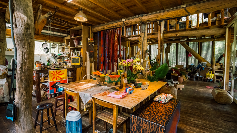
Laiji is home to numerous talented artists and artisans, and DIY experiences at the village workshops are integral to the Laiji tourist experience. The Lan Hou Homestay provides village tours; its manager, Afayi, is also head of the Laiji Community Development Association. Start your experience visit at the Tsou Museum, a quaint single-room thatch-roof structure on the homestay grounds, learning about the tribe’s cultural, artistic, and handicraft inheritance through the variegated heritage artifacts on display.
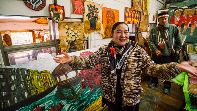
We next spent time admiring the work of warmhearted Yangui, a painter whose home/workshop/restaurant backs onto the homestay grounds. She took up painting after a serious health scare as a form of self-therapy. Yangui prefers painting with her fingers because of the more pronounced 3D effect. Her indigenous-theme works have been sold as far away as the United States, and among her laurels was an invite to participate in a prestigious international artist gathering at the 2008 Beijing Olympics.
At PU-U Workshop, paint your own wood-block wild boar with artist Pu-u Akuyana, who has been in love with this quintessential Tsou-culture symbol since her mother allowed her to raise a mountain boar as a pet when a child. Her boars have hand-carved eye-area and body striping, plus painted renderings of two other key symbols, millet stalks and Mt. Ta, where Tsou souls rest, the mountain’s crest line hand-carved.
Other available art/artisan/DIY experiences include woodworking and making bamboo ware, leather goods, and aiyu fig jelly, a Taiwan-favorite snack treat. Alternative-theme choices include firefly tours, campfires, stargazing outings, and fruit-harvest picks.
Fenqihu & the Alishan Forest Railway
Small, tourist-popular Fenqihu, just north of Highway 18, is the Northwest Corridor’s gateway hub. A town of great character, it was founded as a halfway station, timber-loading point, and repair depot on the Alishan Forest Railway, another of Alishan’s most popular attractions, one of the world’s highest and most picturesque lines. The narrow-gauge railway, a twisting, turning, incredible and improbable feat of engineering, was constructed by the Japanese in the early 1900s during their 1895-1945 period of colonial control. The Chiayi City-Fenqihu section is open [for ticket reservations, call Chiayi’s Beimen Station at (05) 276-8094 or (05) 276-2251; website: https://afrts.forest.gov.tw/TP01_1.aspx].
Getting There & Getting Around
The northern part of Alishan has only very infrequent public-bus services. Twice a day buses run between Chiayi Railway Station and Ruifeng (bus No. 7315, leaving Chiayi at 09:30 and 16:30) and also twice a day between Chiayi Railway Station and Fenqihu (bus No. 7302, leaving Chiayi at 07:10 and 15:10).
The Taiwan Tourist Shuttle (www.taiwantrip.com.tw) service features two routes between Chiayi City and Alishan National Forest Recreation Area via Highway 18: from Chiayi High Speed Rail station (bus No. 7322 – Route A; departures at 10:10, 11:40, and 13:10) and from Chiayi Railway Station (bus No. 7322 – Route B; 11 departures a day between 06:10 and 14:10) with a stop at Shizhuo. From Shizhuo you can take another shuttle (Route B1) to Fenqihu (8 services a day between 10:00 and 14:20). Twice a day, there is also a bus service between the Alishan National Forest Recreation Area and Fenqihu.
Trains of the Alishan Forest Railway depart Chiayi at 09:00 (daily) and at 10:00 (only Saturdays, Sundays, and holidays), arriving at Fenqihu 2 hours and 20 minutes later. Many homestays/B&Bs in the Alishan area will pick customers up in Fenqihu.
Further reading on other sites
Spiritual Travels (by Nick Kembel):
Alishan, Taiwan: Best Sunrise Spots, Hiking Trails and Tea Farms
Find Alishan/Chiayi hotels on booking.com and agoda.com:


About the author

Rick Charette
A Canadian, Rick has been resident in Taiwan almost continually since 1988. His book, article, and other writings, on Asian and North American destinations and subjects—encompassing travel, culture, history, business/economics—have been published widely overseas and in Taiwan. He has worked with National Geographic, Michelin, APA Insight Guides, and other Western groups internationally, and with many local publishers and central/city/county government bodies in Taiwan. Rick also handles a wide range of editorial and translation (from Mandarin Chinese) projects.